
Over the last couple of months we’ve seen three roadworks in Glenorchy – remodelling of the intersection of Marys Hope Road and Kilander Avenue ($54k), the intersections of Pitcairn Street and Montrose Road ($21k), and the installation of safety barriers on Collinsvale and Molesworth Roads ($115k).
According to this media release in August 2020 from the Australian Government, the three projects were funded to the tune of a total of $190k from the Australian Government Black Spot Program. The grants were not conditional on Council contributing any funds.
The media release rather dramatically described the locations as “dangerous crash sites”. I have not found any records of traffic accidents that would have been avoided by the works just undertaken. While the program appears to focus on sites with a history of crashes, the program’s website says about eligibility that the program:
recognises that there are road locations that could be considered as ‘accidents waiting to happen’. Therefore, some program funds may be used to treat sites where road traffic engineers have completed a Road Safety Audit and found that remedial work is necessary. This allows an opportunity for proactive safety works to be undertaken before casualties occur.
https://investment.infrastructure.gov.au/infrastructure_investment/black_spot/black_spot_sites_eligibility.aspx
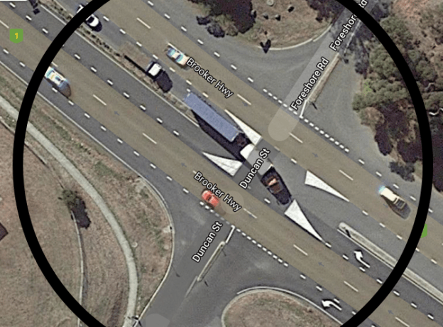
One location that should be considered for the Black Spot Program is the intersection of Brooker Highway with Duncan Street and Foreshore Road.
Council has already committed to constructing a skateboard facility and the Glenorchy Playspace close to the intersection.
Many regard the intersection as dangerous, an accident waiting to happen.
On one corner is Montrose Bay High School and the attendant staff, student and parent traffic.
On another corner is the soon to be upgraded community park with a car park to be doubled in size. A skate park and a regional playspace will dramatically increase the number of vehicles entering.
On another corner is light industry including bus, logistics, and other transport service. Cars, trucks of all sizes, and buses regularly cross the intersection from every direction.
The intersection is the only cross-road on the entire Brooker Highway without a roundabout or traffic lights. This is unacceptable.
The intersection is clearly well known as having safety issues. In the Brooker Highway Transport Plan Partnership Agreement (2011), a list of Safety Projects on page 4 under the heading “Next Three Year Priority Projects” contains the entry “Foreshore Road / Duncan Street intersection safety improvements”. The issue seemed to have been the “common practise [sic] for students to be dropped off or collected directly at the edge of the Brooker Highway” immediately adjacent to the intersection.
The State Government seemingly regarded the issue as serious enough to justify a submission to Infrastructure Australia in 2011 for funds to “upgrade” the intersection without giving details, but estimating cost at $5m.
The Brooker Highway is part of the major urban freight network in the broader north/south freight link and connects southern distribution centres to the northern ports.
The intersection is the cross-roads of Duncan Street and Foreshore Road with the Brooker Highway. It provides access to Montrose Bay High School and its oval. It provides access to facilities in the Montrose Bay Community Park – yacht club, 24 hour public toilets with full facilities, playground, GASP boardwalks, etc.
PS. The image shown for this post comes directly from Google Maps and shows two trucks plus a number of smaller vehicles crossing the intersection.

Update 4/7/2021: Question on notice to Glenorchy City Council
Answers were provided in the agenda for the 26/7/21 Open Council meeting and are included here in italics.
Dear Council
My questions relate to the intersection of the Brooker Highway and Duncan Street & Foreshore Road.
Council has already committed to constructing a skateboard facility and the Glenorchy Playspace close to the intersection.
Many regard the intersection as dangerous, an accident waiting to happen. On one corner is Montrose Bay High School and the attendant staff, student and parent traffic. On another corner is the soon to be upgraded community park with a car park to be doubled in size. On another corner is light industry including bus, logistics, and other transport services. Cars, trucks of all sizes, and buses regularly cross the intersection from every direction.
The intersection is the only cross-road on the entire Brooker Highway without a roundabout or traffic lights. This is unacceptable.
Q1. Does Council acknowledge the increased danger resulting from the upgraded community park and increased traffic volumes?
A: Council acknowledges the Brooker Highway crossing at this intersection is potentially dangerous, and that any increase in traffic using the crossing is likely to exacerbate any danger. However, Council would not proceed with any construction work on the proposed Playspace until all reasonable measures to adequately mitigate any increased risk had been investigated and/or implemented.
Q2. What has Council done to mitigate current danger or future increased danger?
A: The Brooker Highway is a State Highway which is owned and managed by the Tasmanian Government. Council has raised the intersection safety concerns with the Tasmanian Government on many occasions and will continue to lobby for safety improvements.
Q3. Has Council considered nominating the intersection for the Australian Government Black Spot Program? If not, why not?
A: Because the Brooker Highway is a State Highway, Council is not eligible to nominate it for a Black Spot project (the rules of the program mean Council can only nominate roads which it owns and manages under this program). The Tasmanian Government would be required to nominate it for Black Spot or other funding as appropriate. Council would support application lodged by the Tasmanian Government for funding to improve safety at this intersection.
Q4. Has Council lobbied the state government to nominate the intersection for the Australian Government Black Spot Program? If not, why not?
A: Council has raised the issue of safety at this intersection with the Tasmanian Government on numerous occasions and will continue to do so. Council has not formally requested that the State Government lodge a Black Spot Program application, however it is likely that this has been discussed informally at the officer level.
Q5. Did Council consider making traffic in the expanded Playspace car park one-way, utilising a new exit at the southern end? If not, why not?
A: The State government does not allow any new vehicle accesses onto the Brooker Highway, so this option was not considered.
I look forward to Council’s response.
Update 5/7/2021: Submission of nomination form
On 2/7/2021 I had submitted a Black Spot Nomination Form to the Tasmanian Department of State Growth.
I nominated the intersection of the Brooker Highway and Duncan Street stating the nature of my concern as
“The location is dangerous now and will become more dangerous when a playspace and skateboarding facility are built in the Montrose Foreshare Community Park; Council has already called tenders. It is the only right-angle intersection on the
Black Spot Nomination Form (Nature of Concern)
Brooker Highway without a roundabout or traffic lights. Traffic enters and exits the intersection using every available means and it is a miracle that no serious accident has happened.
Corner 1 is the Montrose Bay High School with all its related staff, student and parent traffic.
Corner 2 is the already busy Montrose Bay Community Park with only one access point. Planned expansion by Council will double the size of it’s car park. All access is by car.
Corner 3 contains light industrial companies generating heavy traffic.
Corner 4 contains residential areas generating residential traffic.
Large numbers of cars, trucks and buses cross this intersection; it is an accident waiting to happen.”
The next working day (5/7) I received a phone call from the Manager Traffic Engineering at the Department of State Growth, the staff member who collates nomination forms and prepares them for consideration by the Tasmanian Tasmanian Black Spot Consultative Panel.
He indicated to me that the likelihood of my nomination resulting in any funding was very low for two major reasons – the relatively small amount of funding available compared to the high cost of a solution such as traffic lights, and the large number of nominations expected from other councils and organizations. I was advised to take my chances with State Roads, a part of State Growth, by writing to its General Manager putting my case.
Update 30/8/2021: Comments at Council meeting
During discussion about agenda item 10 traffic safety at the intersection was mentioned by staff and some aldermen in arguing against Montrose Bay as the location for a single regional playspace.
The full text from the meeting agenda p18 is as follows:
During community consultation for the proposed Montrose Playspace, Council
received a number of submissions regarding concerns around traffic congestion in the localised area of the proposed site at Montrose Bay, and also around the safety of the intersection of the Brooker Highway with Duncan Street and Foreshore Road.
Northbound traffic on the Brooker Highway is required to negotiate that intersection
to access the Montrose foreshore. This requires crossing the 4-lane dual carriageway
of the Brooker Highway, which can be difficult.
Additional traffic will already be attracted to the Montrose Bay Foreshore site when
the new proposed Skate Park at that location is completed. Construction of the
proposed Playspace on the foreshore would further increase the volume of traffic
using the intersection, amplifying the current safety concerns.
Council has held concerns about the safety of this intersection for a long time,
however, is unable to take any steps to mitigate the risk given that the Brooker
Highway is a State Highway. Council has raised the safety issues at this intersectio
with the Tasmanian Government, which is investigating potential solutions to mitigate
the risk. However, no time frame for works at the intersection has been given.
While the presence of the traffic safety issue is not insurmountable, it does reduce the
desirability of the Montrose location compared to Giblins Reserve if there is a need to
decide between the two.
Mention in recording of Facebook livestream of meeting:
1:03:00 Alderman Richardson
“The pity of this is that it’s disappointing that Montrose Bay has this traffic concern and, can I just say, that traffic concern has been pointed out by Montrose Bay, and they’re still fighting it, and Council really needs to push that with the State Government, and something needs to be happening in that space before somebody’s killed.”
1:03:30 Mayor
“Director, would you like to explain what Council’s been doing to try to work towards that?”
1:03:31 Director Infrastructure and Works (Emilio Reale)
“We have been lobbying State Government for some time about that intersection. It is a bit of a complex issue because of the speed limits, school zone, and the way the intersection is aligned.
However at the last traffic management catch-up we’ve had with State Growth they did indicate that they have now got traffic lights for that intersection on their forward program but they did not indicate, it won’t be this year and it won’t be next, but it is on their list now to investigate.
So it is progressing and they’ve now recognized that because they keep a record of crash history, and that is a high volume site, so they are going to address it, and there’s nothing stopping Council looking at future development in that area once we know the traffic situation has been dealt with.”
Update 20/12/2022: Response from Department of State Growth to request for information
An email to the Department of State Growth resulted in this response from the “stakeholder consultant” employed by the department for the project.
I have been provided with your details and understand you are seeking information regarding the Brooker Highway/ Foreshore Road/Duncan Street intersection. I will be working with the project team during the detailed design phase, which is due to commence early next year. Projects such as this move to the construction phase once funding is received, and this project has not yet been funded so I’m unable to provide you with any detail regarding when construction is likely to occur or what the final design will look like. It is an important future project, and the Department of State Growth has engaged a team to finalise the design and consult with key stakeholders, so it is ready to be constructed as soon as funding becomes available. I will be able to provide more information on the project when the design is finalised.
Email 20 Dec 2022 12:10pm
Traffic statistics
A variety of traffic statistics at a location close to the intersection can be found on the internet where the Department of State Growth publishes data. The location is described in the website as:
A0090171P
a continuous classified counter located at a two way road [N/S] in Rosetta, Glenorchy on A0090, 390m W Of Foreshore Rd [UTS L10/ 7.76 – 9.21]
Use this link to access the data for that location. There is even data relating to the amount of traffic travelling at various speeds. Have fun.
References
Brooker Highway Transport Plan, Feb 2011. DIER. Page 17.
Glenorchy City Council Open Meeting July 2010 agenda. Page 236+. Adoption of Brooker Highway Transport Plan.
Brooker Highway Transport Plan Partnership Agreement, 2011. Page 4. “SAFETY PROJECTS”.
“Police investigating two vehicle crash on Brooker Highway at Montrose“, Tasmania Police Media Release 22 April 2020 .
Glenorchy City Council Annual Report 2009-2010. Page 4. Report on Council’s work with DIER on development of the Brooker Highway Transport Plan.
Glenorchy City Council Open Meeting April 2020 minutes. Page 4. Answer to public question on notice regarding intersection.
State Government Submission to Infrastructure Australia 2011. Pages 33,34.
Traffic volume reports 1982- . Department of State Growth. Published at “geocounts.com”.
