

Council owns the property at 261 Main Road, Austins Ferry, a property known in the past as “Nortonville”. While its total area is just over eight hectares, only 7.14 hectares is available for development.
It is one of the largest remaining parcels of undeveloped land inside the Urban Growth Boundary that is owned by Council and potentially suitable for residential development.
Council has designated a large part of the property an “Off-Lead Dog Exercise Area” and given it the name “Austins Ferry Park”. Regularly mowed but certainly not developed!
In March 2022, Council decided to begin an investigation to determine whether it is suitable for disposal.
In parallel with that process, it has worked to “clean up” the land to remove any impediments to disposal. According to the minutes of July 2024 Council,
“Council has undertaken a contamination report on the land. All contaminated soil has now been removed from site and awaiting written confirmation. An in-ground fuel tank has been removed and the site remediated.”
The same minutes state
“potential heritage values at the 261 Main Road site (a well, an oak tree and possible structural remains) which means the site warrants further investigation for listing as a ‘Place of Archaeological Potential’.”
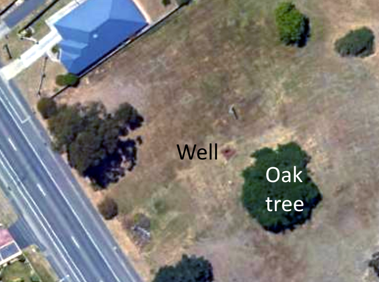
According to the Council’s 2009-2010 Annual Report, Council had asked its Heritage Officer to investigate a water well on the property as a “potential heritage site”. The well is currently covered for public safety (the image for this post shows the wire and plastic webbing used). Underneath is a circular well lined with dry stone, about a metre across and less than two metres deep. I couldn’t find the “possible structural remains”.
But even if the well and tree were found to require protection, their location in the far western corner would only slightly reduce the land area available for development.
So an investigation apparently did begin 15 years ago. According to a recent email from Council, the current investigation is being carried out by external experts and is expected to be finished in the first quarter of 2025.
But what is a ‘Place of Archaeological Potential’ and what are the consequences of a declaration?
The State Planning Provisions contains a Local Historic Heritage Code. Its purpose is to “recognise and protect the local historic heritage significance of local places, precincts, landscapes and areas of archaeological potential”.
It defines Place of Archaeological Potential as:
“a place that is a site, precinct or parcel of land that has been identified as having the potential to contain archaeological evidence that provides information about the past and is:
(a) shown on an overlay map in the relevant Local Provisions Schedule; and
(b) listed and identified in the places or precincts of archaeological potential list in the relevant Local Provisions Schedule.”
Note that the Code does not apply to Aboriginal heritage values.
Glenorchy’s Local Provisions Schedule contains a list entitled “GLE-Table C6.4 Places or Precincts of Archaeological Potential”. You can read that list through this link.
Top of the current list is the “Ashburton farm complex”. Much of the land it contains is in the old Claremont Primary School site where a permit for a major residential development was granted by Council in April 2021. So being declared a Place of Archaeological Potential does not preclude even major development on a site.
According to the March 2022 Open Council agenda 261 Main Road is a “very large, 7.14-hectare block which is zoned as a combination of Light Industrial 58%, Open Space 24%, General Residential 11%, Rural Living (Zone A) 7%.”
At that meeting Council decided to “authorise a community engagement process to be undertaken to identify any community concerns about the potential disposal” of the property. This in line with Council’s policy on Disposal of Council Land.
That decision was the result of a “strategic review of land suitable for disposal for housing” by Council officers.
The agenda described the property as “land with potential for significant multiple dwelling housing developments and are considered priority potential sites for increasing the supply of land for housing.”
The report goes to state that Council will soon start “preliminary public consultation process to identify any significant concerns about the potential sale” of that land.
Council’s own Statement of Commitment on Housing (adopted 30 January 2023) lists actions Council intends to take. The last says Council will “release surplus Council owned land to increase residential land supply for housing.” There is no evidence that Council has considered the property for residential development of any sort or in fact regards it as surplus.
Given the current housing crisis, it would be a tragedy if 261 Main Road were to become another Whitestone Point, another large residential subdivision to be sold as a commercial development. Half of the property slopes down to the river with fantastic views over the river. Too good for social or affordable housing? It would be tempting for Council to “land bank” the property to maximize its return on disposal.
It is hard to understand why Council has never shown visible signs of urgency in putting the property to a useful purpose. Perhaps we will see some movement after Council receives the report from the investigation into the heritage values of the property early this year.
Sources
May 2023 Council agenda (page 22).
