Council’s Parking Plan is a weird beast indeed

Council staff are now finalising a draft Parking Plan (GPP) for our city. If you want to learn more about Parking Plans there is precious little to go on. In this post I will attempt to describe the weirdness of the Parking Plan concept.

The concept of a Parking Plan is based on a single paragraph (read the original) which says:

the site is subject to a parking plan for the area adopted by council, in which case parking provision (spaces or cash-in-lieu) must be in accordance with that plan;

In essence, it says that if a proposed development is in a place covered by a Parking Plan then some or all of the usual State rules for off-street parking might be over-ridden by the Parking Plan.

The first weird thing … there is no other explanation or definition of what a Parking Plan looks like or the information it contains. Council’s approach has been to base its structure on the look of the Parking Code in the State rules.

The second weird thing … is that it is “adopted by council”. Councils have taken this to mean that the entire process of designing, writing, and putting a Parking Plan in place is controlled by council.

The third weird thing … is that our council has, despite the Parking Plan affecting the application of an integral part of the city’s planning scheme, used a variation of its usual policy development process so far … staff draft, consultation with public and stakeholders, etc.

The next weird thing … is that council has, as is usual for its policies, set a review period (four years). Reviews of many council policies are staff reviews only, done with no public visibility and presented to an open council meeting as a fait accompli. This will not do for the Parking Plan which must incorporate the same level of public consultation used for the first version.

The Parking Plan concept seems to be a fudge to the state planning scheme to allow councils to tweak off-street parking rules in their city without any external oversight by the Tasmanian Planning Commission (or anyone else for that matter).


Given the lack of information about Parking Plans, some questions arise.

The text I quoted above referred to “a Parking Plan”, not “the Parking Plan”. Does that mean that Glenorchy can have more than one Parking Plan, each relating to specific portions of the city?

If so, it could create a new Parking Plan quite quickly without waiting for the scheduled review date of the first plan. That might be useful. For example, it would allow council to create a Parking Plan for the site of any proposed development if it regarded the development as being of sufficiently great significance to the city?

And finally, there is the interaction between council and the planning authority. If council adoption of a Parking Plan takes immediate effect, it could create a new Parking Plan to suit a Development Application that council has received while assessment is still under way.


In conclusion, many readers might find a discussion on off-street parking a little weird. It may be … but it is also an internationally controversial and contested subject.

Many cities, large and small, across the world have removed all mandatory off-street parking requirements in part or all of the city. Many others have reduced the requirements. Many others have ongoing argument and debate.

A couple of the most common arguments for removing/reducing mandatory off-street parking requirements are:

a) Reducing the amount of space for parking provides more space for living space. What is not used for parking can be used for accommodation.

b) The developer knows best what amount and type of parking is most appropriate for the proposed development. So why not let them decide the quantity? Council’s interest should be in the size, design, and safety of any parking spaces.

It is of course not as simple as this in reality. For example, if there is little parking provided for a residential development then the availability of travel options such as public transport becomes an important topic for those without their own vehicle.

This is no trivial matter and should be treated seriously.

Councillor Question Time

At open council meetings the public can ask questions about council business in Public Question Time.

Councillors have to wait until the end of the meeting for their turn. It can be worth waiting for because most formal business has been dealt with, and councillors tend to relax a little. And the topics raised can surprise.

It is a time when councillors can use questions to raise matters of interest, gauge the level of interest in those matters, or finally, if they perceive a positive reaction around the table, pursue the matter in a workshop or future council meeting.

By asking a question a councillor can start a conversation around the table. Unlike most of the meeting that conversation has few rules and can flow freely. It can sometimes feel like a workshop on the run.

The question can be dealt with in various ways.

The question can answered outright by someone in the room.

The question can be taken on notice giving staff time to research and formulate a comprehensive and accurate response.

The discussion can simply fizzle out through lack of interest.

A councillor might be tempted to try to turn talk into action by moving a motion on the spot. Not on.

A general rule of council meetings is that a councillor cannot create a new substantive motion out of thin air (they can move procedural motions though – look it up). That rule is intended to make it difficult to ambush the meeting with a motion that councillors and staff have not had an opportunity to research or discuss or get advice on. The rule can be broken only in an exceptional situation on a serious and urgent matter.

Alternatively, if a councillor wants to force a debate they can give notice of motion for a future council meeting.

Sometimes a councillor might suggest a workshop to explore the question with the benefit of research and staff expertise. If whoever is in the chair (usually the mayor) senses general agreement then the CEO may add the workshop to their meeting action list. An “informal” decision is made. The conversation moves on.

In some meetings the councillor question time is the most interesting (and sometimes entertaining) section, worth the wait.

Did the rules not apply to Hidden Garden Estate?

On 11 November 2025 a full page article appeared on page 7 of the Mercury newspaper telling the story of the closure of the Hidden Garden Estate, a major wedding venue in Berriedale Tasmania. The article was surprisingly balanced, and did not directly blame the Glenorchy City Council for the closure. Local government is often an easy target for those wishing to redirect the blame for a business failure.

The post in the business’s Facebook page announcing the closure, and quoted in full by the Mercury, did however spend many words attempting to describe Council as unwilling to  make any concession or give the owners time to sort it out, and create an image of a pedantic legalistic inflexible unfeeling organisation.

The owners had not gained a permit for either the major renovations or for occupancy after the work was done. Did the rules not apply to them?

The owners should feel relieved that those who had little choice but to cancel were satisfied with refunds and have not taken legal action. They clearly suffered from actions (or more accurately lack of action) of the owners. Imagine cancelling or relocating a wedding at a month’s notice!

PS. This content of this post is based on the Mercury article mentioned.

Mandatory off-street parking requirements more trouble than they’re worth

Tomorrow (10/11/2025) I will attend a meeting of the Glenorchy Planning Authority (GPA), a meeting with exactly one item on the agenda.

An item I find utterly exasperating.

An item necessary because the building in question, according to planning rules,  has too few parking spaces for its use.

An item necessary despite no response from any member of the public when the Development Application (DA) was advertised in the Mercury.

An item necessary because no Council staff member has the power to “determine applications with residential car parking discretions” (full list of delegations). Hence the Planning Authority must decide the matter.

But the situation arises originally because the Tasmanian Planning Scheme (TPS) contains an algorithm for calculating the minimum amount of off-street parking required for the use to which the site will be put. If the amount of parking in a DA is not at least as much as the algorithm says, the DA does not have an “acceptable” parking solution and must be assessed against the “performance criteria”. Take a look at the algorithm and the table C2.1 it refers to; they both fit on only eight A4 pages.

The Parking Plan

What is remarkably timely about this particular DA is its timing. It comes while council staff are preparing a Parking Plan for the city of Glenorchy, a plan which is intended to “override the number of car parking spaces specified in the planning scheme and reduce car parking numbers in specific areas.”

Council employed GHD, an international consultancy, to “determine and summarise potential adjustments to minimum car parking rates for development applications within key areas of the Glenorchy LGA that may be applied in a Parking Plan for the municipality” and provide a report to council on the results. You can read the 12 August 2025 version of the GHD report on Minimum Parking Rates.

The GHD report states “evidence does not support a minimum parking requirement” and consequently shows, in order from most effective to least effective) options as:

  1. Removal of car parking minimum rates
  2. Partial removal by-location of car parking minimum rates
  3. Partial removal by location and size of development
  4. Reduction in minimum-parking rates (by location and/or use class)
  5. Adopt widely accepted rates where appropriate

What is particularly disturbing about the first draft of the parking plan is that it adopts, without any explanation, the option GHD regards as the least effective, option 5, “Adopt widely accepted rates where appropriate”. The result was a decrease across the board of about twenty percent.

The first draft plan, if adopted essentially as is, would not improve the situation. The item on tomorrow’s planning authority agenda would still come to the GPA for decision.

We heard at the parking plan workshop that council were being encouraged to “be brave” in their decision-making. I hope that council will do so, change its mind, and accept the consultant’s number one recommendation to reduce minimum off-street parking requirements by 100% ….. all the way to zero.

Now for a Walking Infrastructure Plan

Katoomba Crescent laneway (entrance on Katoomba Crescent). 15/7/2025.

At its June 2025 open meeting council “endorsed” (whatever that means) the final draft of a Glenorchy Cycling Infrastructure Plan (GCIP) which contained no timeline, no description of what type of infrastructure might be where, and consequently no budget. It is in effect a vision for where cycling infrastructure might sit geographically long-term, but without any of the data needed to make a Priority Project. Still better than nothing and sufficient to satisfy, for now, the well organized lobby groups (such as Cycling South and Tasmanian Bicycle Council) in southern Tasmania.

By carefully reading the GCIP you will find the word “walking” mentioned 38 times, usually in the phrase “walking and cycling”. It seems the authors believed that the GCIP might serve as an infrastructure plan for all active transport, not just cycling.

It takes a few moments of thought to realize that those who walk have vastly different needs and considerations from those who ride. But it is not at all clear how those who often or mostly walk have their differing needs recognized by any level of government. There is a Facebook page “Pedestrian & Public Transport Users Group” that appears to focus exclusively on public transport. A recent addition is an organization known as Hobart Streets which shows some promise. So no organized lobby groups for those who walk.

Let me clear. I am not talking about tracks or trails designed purely for sport or recreation. Council already takes management of walking trails seriously, so seriously that you could say that Council has 4 R’s – Roads, Rates, Rubbish, and Recreation – instead of the usual three. I am talking primarily about people using “walking” as a way of getting about in their day-to-day life. To the shops. To the bus stop. To visit. To work. To school. To play sport. To the doctor. To study. etc. etc.

Infrastructure

It is easy to forget that there is a great deal of infrastructure in our city whose prime purpose is to cater for pedestrians. We drive past it. We walk over it. We can easily take it for granted.

Footpaths are the most ubiquitous. They are everywhere, well almost everywhere, and council does have policy documents related to them. The basic Footpaths Policy provides “guidance on the standards required for the provision and construction of footpaths and kerb ramps”. That policy refers to a footpath hierarchy defined exactly as follows:

  • Category 1 – CBD: footpaths in the main street in the CBD where there is significant business and pedestrian activity.
  • Category 2 – Primary: high pedestrian activity within the CBD areas and includes direct pedestrian links between the key CBD zones, such as the Intercity Cycleway.
  • Category 3 – Secondary: footpaths that provide the best link between key destinations and facilities (e.g. bus stops, local shops, schools, playgrounds, etc.)
  • Category 4 – Local: footpaths generally in the residential streets and any footpaths which are not included in the other categories above.

Notice the reference to the Intercity Cycleway as a “footpath”. Any regular user of the cycleway would regard it as “contested” in terms of whether pedestrians or cyclists have priority.

The Footpaths Policy also states that a “digital map of footpath hierarchy will be … maintained by Council”. It would be similar to the map underlying the Cycling Infrastructure Plan but not developed with any public consultation. The only map in Council’s map website is the Infrastructure Map which shows roads and kerbs but no footpaths.

The Footpath Trading Policy and Guidelines concern how businesses can operate on footpaths.

But there is much more infrastructure which exists to serve pedestrians.

  • Bus stop approaches (frequent destinations)
  • Kerbs (including ramps, kerb cuts and extensions)
  • Laneways and paths crossing blocks (e.g. Katoomba Crescent lane way)
  • Pedestrian crossings (with or without signals)
  • Pedestrian overpasses (e.g. Brooker near Montrose Bay) and underpasses (e.g. Brooker near Strathaven)
  • Pedestrian priority streets (access by vehicles limited and low speed)
  • Pedestrian refuge islands
  • Pedestrian safety and comfort (e.g. lighting, shelter)
  • Pedestrianized streets (vehicles excluded)
  • Rules regarding pedestrian priority (or not)
  • Spaces shared with cyclists (separate?)
  • Wayfinding (signage etc)

All this pedestrian-oriented infrastructure demands a pedestrian-oriented Infrastructure Plan.

Taking the bigger view

Before people walk, they think about how they will get from the starting point to the destination – everything in between – the route.

It is time for council to think the same way, in terms of routes, not simply individual pieces of infrastructure mitigating local issues.

It is time for walking infrastructure to be planned using routes as the primary focus, not apparently piecemeal addition here and there according to demands or complaints from residents.

Planning could in fact move to the next level via networks where integration and interconnection of major walking routes comes into play. This approach has been used elsewhere (such as Victoria (Australia), Queensland, and Dundee (Scotland)) so it has been tried and tested elsewhere.

A focus on the elderly

It is generally accepted that pedestrians are the most vulnerable road users. And older pedestrians are the most likely to be injured or killed in a crash. Furthermore, most demographic projections predict an increase in the proportion of older people in Glenorchy’s population. The State government’s Population Policy website says that for Glenorchy the “population of people aged 65 and above is projected to increase from 8,862 (17.4% of the LGA population) in 2023 to 12,074 (22.2%) in 2053.”

Clearly when considering pedestrian safety on roads, there must be a focus on the particular vulnerabilities of the older members of our community.

In conclusion

An interesting possible result of this type of planning is that it might trigger applications to the Black Spot Program for “walking” black spots in addition to the current almost exclusively “driving” black spots?

The State Government in their Active Transport Strategy tends to universally use the phrase “walking, wheeling and riding” as if they have identical requirements in all contexts. While many cycling and walking routes will overlap, the needs of pedestrians and cyclists differ dramatically and may even conflict.

Those differences demand a Walking Infrastructure Plan specifically designed for those for whom walking is important. Yes – a Glenorchy Walking Infrastructure Plan. The absence of an active lobby group should not delay council. Work must begin immediately.


Original sources

1. Council Footpaths Policy (downloaded 4/7/25)
https://www.gcc.tas.gov.au/wp-content/uploads/2024/10/Footpaths-Policy-2024-.pdf

2. Footpath Trading Policy (downloaded 4/7/25)
https://www.gcc.tas.gov.au/wp-content/uploads/2022/06/Footpath-Trading-Policy.pdf

3. Footpath Trading Guidelines (downloaded 4/7/25)
https://www.gcc.tas.gov.au/wp-content/uploads/2022/06/Footpath-Trading-Guidelines.pdf

4. “Planning for Walking”, Chartered Institution of Highways and Transportation 2015
https://www.ciht.org.uk/media/4465/planning_for_walking_-_long_-_april_2015.pdf

5. Victoria Walks – https://www.victoriawalks.org.au

6. Public domain map showing laneways and cycleways – https://www.openstreetmap.org/#map=14/-42.81996/147.25748&layers=C

End.

Glenorchy is a city. Who cares?

When Molly Kendall and Harry Quick attended their first council meeting after being elected at the 2022 election, they both declared their desire to be referred to as “Councillor” rather than “Alderman”.

According to the 1993 Local Government Act: “A person elected to a city council is a councillor but may be known as an alderman.”

Although Kendall and Quick were within their rights to ask to be called “Councillor”, it did trigger considerable discussion among those we now quaintly refer to as “elected members”.

Some were quite passionate about wanting to be called “Alderman”. Some didn’t seem to care. I still don’t understand why some took the subject so seriously, probably because I’m a newcomer to Glenorchy having lived here for only 40 years. I was curious.

A little background.

City status was granted to Glenorchy on October 24, 1964, exactly one hundred years after it was first proclaimed a municipality (the third city proclaimed in Tasmania).

The definitive list of Tasmanian councils appears in Schedule 3B of the Local Government Act and currently contains

  • Burnie City
  • Clarence City
  • Devonport City
  • Glenorchy City
  • Hobart City
  • Launceston City

Clarence is an outlier because you will not find “Clarence” on any map I’ve seen.

And you’ll find that Hobart Council has special status in various situations.

Here are the criteria that must be satisfied by a “city” in Tasmania. The Board referred to is the Local Government Board.

38.   Criteria for city status
For the purposes of section 214D(3) of the Act, the Board may make a recommendation relating to the declaration of a municipal area or part of a municipal area as a city if all of the following circumstances exist:
(a) for 5 years immediately preceding the Board’s review, the municipal area had a population of at least 20 000 persons;
(b) at least 60% of the population of the municipal area lives in an urban area;
(c) an elector poll conducted on behalf of the council has indicated that the majority of electors favour the recommendation.

[ Section 38 of the Local Government (General) Regulations 2015 ]

Back to the original question: why do some care so much?

Is it a feel-good thing? Do the residents of Glenorchy have greater pride in where they live because it is a city?

Does it add to the Glenorchy brand (whatever that is)? Is it about having Glenorchy perceived as an urban centre rather than simply a collection of dormitory suburbs? The G brand needs all the help it can get because G is geographically simply an extension of the City of Hobart.

Does it give Glenorchy extra privileges, advantages, opportunities or powers? Commonwealth legislation?

I suppose that being a city means that Glenorchy can be a sister city to another city (Australian or overseas). Glenorchy can’t have a sister city if it isn’t a city.

I still don’t get it … so I shall ask Council. I’ll keep you posted.


Here are my questions to Council sent on 7 February 2023 and the answers I received.

My questions relate to Glenorchy’s city status. It was apparently a matter of civic pride when Glenorchy received that status in October 1964. I’m interested in whether our city or its residents have received any benefits as a result. As far as I can tell, it allows (a) Glenorchy to have a sister city if it wishes, and (b) councillors to call themselves “Alderman” if they wish. I’d like to know more.

Q1.      Is Council aware of any circumstances in which it is treated differently by any state or commonwealth government body as a direct result of Glenorchy’s city status?

A:        No. Under Commonwealth grants, the entire state of Tasmania is classified as ‘regional’ and there is no differentiation between cities and other municipalities.

Q1a:   If so, please provide some examples?

A:        For example Commonwealth assistance grants are allocated according to a complex model that takes no account of City status.

Q2.      Is Council aware of any powers, authority, entitlements or privileges that it would not have if Glenorchy did not have city status?

A:        Under the Local Government Act, cities, with exception of Burnie, have a larger body of councillors (10-12) and may use the title of Alderman.

Q2a.   If so, please provide some examples?

Q3.      Is council aware of any income from any source that it would not receive if it did not have city status?

A:        Glenorchy is part of the Hobart City Deal that carries Commonwealth government funding. However, if Glenorchy was not a city, but had the same commercial/industrial/residential composition and proximity to the Hobart CBD it would still likely have been part of the Deal.

Q3a.   If so, please provide some examples?

A:        As above.


Now make it safe for pedestrians at Montrose Bay

Now that the efforts of Council and others appear to have finally persuaded the State Government to make the Montrose Bay Park entrance safer for drivers, maybe it can do the same for those who do not drive.

The State Government allocated funds for a project to improve safety at the intersection. The Department of State Growth (DSG) have had a draft design for the intersection to make it controlled by traffic lights. They’ve had that design on their books for years. Enquiries to DSG have always elicited the same response – “we’re waiting for the funds”.

The State Government (and many others) will claim that the proposed traffic lights will make the intersection safe for those on foot, on bike, on scooter, or on skateboard – in other words, for what is now called “active transport”.

Most who have attempted to cross the Brooker Highway on foot will tell a story of being extremely cautious, extremely nervous, extremely tentative. And they will say that using traffic lights does little to reduce the tension. 

Any reasonable person could easily come to the conclusion that the Brooker Highway has one prime purpose – to allow traffic to enter and leave Greater Hobart as quickly as possible. It is a facility for traffic. It is utterly ludicrous to suggest that the Highway was in any way designed for the safety of people moving around in any other way, certainly not on foot.

So the proposed traffic lights may help drivers feel safer at Montrose Bay but will do little for pedestrians.

Which brings me to the pedestrian overpass at Montrose Bay High School. The only place in a two kilometre stretch of highway where you can cross without walking on the road surface.

A passing glance at the overpass might fool a casual observer that the overpass is the solution. And it is in roughly the right place, not too far from the school and Montrose Bay Park.

View of pedestrian overpass at Montrose Bay High School facing north. 2025.

But on a second glance, the sets of stairs on each side of the highway will become evident. Those stairs are an impassable barrier for anyone with any significant mobility issues.

That problem has been recognized officially. That overpass is not DDA-compliant, in other words, not compliant with the Commonwealth Disability Discrimination Act 1992. This is after all what the State Govt’s own Brooker Highway Transport Plan said back in February 2011.

You might look at its title and think that the DDA is just for the disabled. Not so. It is all about access. It is about everyone having the right to “have access to places used by the public”.

To learn more about the DDA, take a look at the website of the Australian Human Rights Commission.

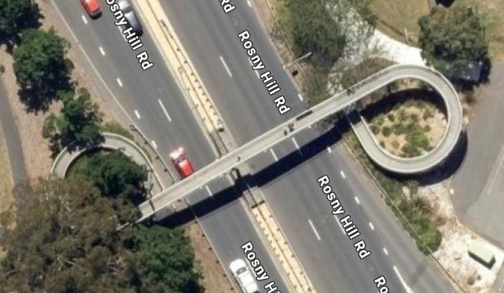
To see an aerial view of a compliant overpass you need go no further than Bellerive.

Pedestrian overpass on Rosny Hill Road 2025.

It has become clear over many years that no state government of any political persuasion has had any interest in the safety of pedestrians on or around the Brooker Highway. Their strategy has been to stonewall any request for change and rely on lobbyists giving up in frustration.

Council must now add the provision of a DDA compliant overpass to its priority list for funding.

It must not put up the white flag on the safety of its residents – and everyone else from the region – who go to the high school or park.

How much of Glenorchy’s plastic is recycled? (part 3)

I asked at the January 25 open council meeting if Council would provide me with information about the nature of the statistical report they receive now and then from Cleanaway.

Here is the complete response.

“you asked, which was “what is the nature of the report Council receives from the recycling facility Cleanaway” we committed to seek permission to provide you with the headings of the report, so you have an insight into the nature of the report.  Cleanaway agreed to providing this information to you.

This report has commercial in confidence information which we do not have permission to publicly release.  Council sought permission to provide the topics that are reported on, so you have an insight to the nature of the report.

The report content is:

Council Monthly Tonnes In
Commercial Tonnes In
Total Tonnes In
Council Monthly Tonnes In – Percentages
Commercial Monthly Tonnes In – Percentages
Glass Out
Waste Out
Cardboard In/Out
Commodities Out
Standard Reporting
Incident Report”

Email received 6 Feb 2025 3:16pm

The brevity of this response begs more questions than it answers. In the faint hope of further clarification I asked these questions as “questions on notice” in February 2025 and received answers (shown in red) in the agenda of the March 2025 Open Council.

  • When the word “in” appears, where is the measured material going from and where is it going to?
    Answer: The material comes from the 12 southern Tasmanian Councils. Council is not informed of where it is going to.
  • When the word “out” appears, where is the measured material going from and where is it going to?
    Answer: The material is going from the Material Recovery Facility in Derwent Park Road. Council is not informed of where it is going to.
  • What is the definition of “commodities” in the context of the report?
    Answer: Commodities is made up of cardboard, paper, metals and plastics.
  • Does Council have any data relating specifically to reuse of plastics recovered by Cleanaway at its MRF? If so, can you describe it’s nature?
    Answer: Council does not have this data.
  • Does Council have any data relating to reuse of any materials whatsoever recovered by Cleanaway at its MRF? If so, can you describe it’s nature?
    Answer: Council does not have this data.

How much of Glenorchy’s plastic is recycled? (part 2)

I’ve written before about wanting to know whether I should bother to put plastic into my yellow bin. I finally learnt on October 24 (use this link) that

“Cleanaway recovered during the 2024 financial year 1,208 tonnes of rigid plastics (HDPE, PET, PP).”

This response was intensely disappointing because (a) it provided no statistics relating to Glenorchy. and (b) it only referred to plastic that had been “recovered”.

In plain English, “Recover means to separate the wanted stuff from the unwanted stuff”. So I still have no idea how much of that “recovered” plastic has been put to a new use.

So I’ve tried a different approach. I asked, during public question time, at the January 25 open council meeting if Council would provide me with information about the nature of the statistical report they receive now and then from Cleanaway. In other words, what were the statistics that Council received?

I was told that Council would ask Cleanaway for permission to do that. It certainly appears that Cleanaway is under no obligation to provide the public any data whatsoever about how successful they are in having their “recovered” plastics reused.

I look forward to Council’s (i.e. Cleanaway’s) response.

Govt calls for tenders for new Park and Ride in Claremont

On Saturday the State Govt called for tenders to construct the new Park and Ride along Link Road in Claremont. Here is a portion of the overall key plan for the build from the tender documents.

It seems like a bad time to publish a tender with companies in the construction business winding down for the Christmas break.

But I guess the govt wants to get the Park and Ride built and run in before they finalize the design for the new Sports Centre over the road near Claremont College and start building that.

Only time will tell if people actually use the Park and Ride. And let’s hope that bus services are improved on Link Road to encourage people to use it. Very few Metro services travel the full length of Link Road.