Tag Archives: cycling

Do wheels rule on the Cycleway?

What follows is a copy of a Facebook post written last year as a rant about the way cyclists on the Cycleway treat those on foot.

As a regular walker on what is officially called a Cycleway but in reality is a shared space, I regularly feel uncomfortable when overtaken from behind by a cyclist or scooterist. No bell, no warning, just a quiet whoooshh as they pass!

It might not be so disconcerting if they slowed as they pass but that is extremely rare. And speeds seem to be increasing so much so that a direct collision would be damaging, sometimes speeds that might not be legal on a public road.

It seems that we pedestrians are viewed as interfering with their riding or scootering pleasure, obstacles to be navigated.

There is some irony in seeing cyclists treating pedestrians in ways they would not accept from drivers.


There was such a variety of responses to the Facebook post that I decided to find out exactly what rules do apply to those of us who use the Cycleway, whether walking, cycling or scooting. Legally I mean. For example, does the Cycleway have any road rules about how we behave and how we deal with each other.

Since most of the Cycleway is in Glenorchy I supposed that Council would have the knowledge through an interest in the safety of their residents. So I asked them. Their response simply referred me to the legislated Road Rules.

It turns out that the Tasmanian Road Rules do apply to the cycleway for people walking, riding, or scootering. You can read the road rules online. The current version is 2019.

To start with, the Cycleway is not a road (because roads are mainly for “driving or riding of motor vehicles”), But it is what the legislation calls a road-related area because it is “open to the public and designated for use by cyclists”. No mention of drivers or pedestrians so I don’t know what this designation means for the Cycleway.

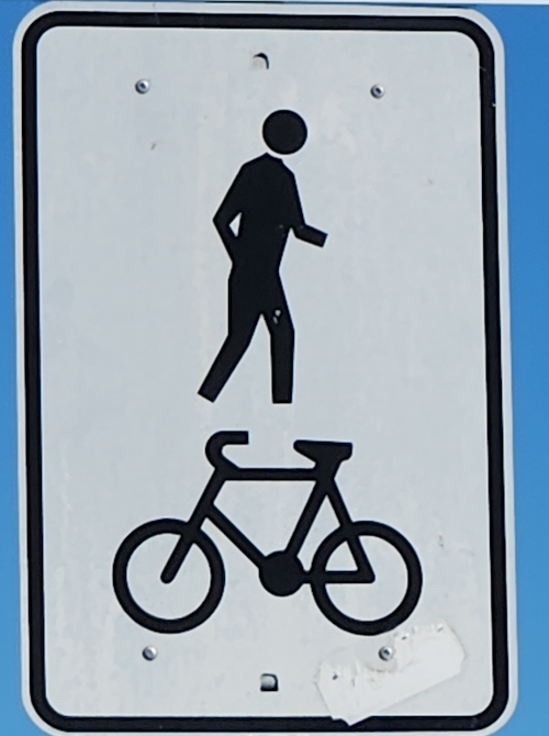
And because the Cycleway is “an area open to the public … that is designated for, or has as one of its main uses, use by both the riders of bicycles and pedestrians” and has these signs beside it, it is also a “shared path” (Rule 242). That means that pedestrians are allowed to use the Cycleway and have just as much right to be on it as any cyclist.

Tasmanian Shared Path sign 2026.

Part 15 of the Road Rules, entitled “Additional Rules for Bicycle Riders” :

  • Rule 250 says that the “rider of a bicycle riding on a … shared path must (a) keep to the left of the footpath or shared path unless it is impracticable to do so; and (b) give way to any pedestrian on the … shared path.”
  • Rule 251 says “The rider of a bicycle riding on a … shared path must keep to the left of an oncoming bicycle rider … on the path.”

So, despite what many think, some rules do apply.

My thoughts then turned to the issue of speed. Are there any speed limits for any type of user of the Cycleway?

Rule 244O says that someone “must not travel in or on a personal mobility device … on a shared path … at a speed exceeding 25 kilometres per hour.” But the dictionary for the rules says personal mobility devices do “not include a bicycle, motorised scooter, motorised wheelchair or wheeled recreational device”. I couldn’t find any other reference that might be relevant for the Cycleway.

And finally, there is the question of whether cyclists should attempt to warn pedestrians using a bell (or something else), a question that can surprisingly arouse strong emotions. In my experience, hearing a bell is a rare event – but a welcome one from a cyclist approaching from behind particularly if done early and not seconds before the overtake. The bell does not however absolve the cyclist of prioritizing safety over speed, slowing for the overtake.

In conclusion, not only is there no acknowledgement that bicycle speed could increase the danger to pedestrians, there is no signage whatsoever on the Cycleway reminding cyclists that they are sharing the path with walkers, and that their riding speed and behaviour matters.

Now for a Walking Infrastructure Plan

Katoomba Crescent laneway (entrance on Katoomba Crescent). 15/7/2025.

At its June 2025 open meeting council “endorsed” (whatever that means) the final draft of a Glenorchy Cycling Infrastructure Plan (GCIP) which contained no timeline, no description of what type of infrastructure might be where, and consequently no budget. It is in effect a vision for where cycling infrastructure might sit geographically long-term, but without any of the data needed to make a Priority Project. Still better than nothing and sufficient to satisfy, for now, the well organized lobby groups (such as Cycling South and Tasmanian Bicycle Council) in southern Tasmania.

By carefully reading the GCIP you will find the word “walking” mentioned 38 times, usually in the phrase “walking and cycling”. It seems the authors believed that the GCIP might serve as an infrastructure plan for all active transport, not just cycling.

It takes a few moments of thought to realize that those who walk have vastly different needs and considerations from those who ride. But it is not at all clear how those who often or mostly walk have their differing needs recognized by any level of government. There is a Facebook page “Pedestrian & Public Transport Users Group” that appears to focus exclusively on public transport. A recent addition is an organization known as Hobart Streets which shows some promise. So no organized lobby groups for those who walk.

Let me clear. I am not talking about tracks or trails designed purely for sport or recreation. Council already takes management of walking trails seriously, so seriously that you could say that Council has 4 R’s – Roads, Rates, Rubbish, and Recreation – instead of the usual three. I am talking primarily about people using “walking” as a way of getting about in their day-to-day life. To the shops. To the bus stop. To visit. To work. To school. To play sport. To the doctor. To study. etc. etc.

Infrastructure

It is easy to forget that there is a great deal of infrastructure in our city whose prime purpose is to cater for pedestrians. We drive past it. We walk over it. We can easily take it for granted.

Footpaths are the most ubiquitous. They are everywhere, well almost everywhere, and council does have policy documents related to them. The basic Footpaths Policy provides “guidance on the standards required for the provision and construction of footpaths and kerb ramps”. That policy refers to a footpath hierarchy defined exactly as follows:

  • Category 1 – CBD: footpaths in the main street in the CBD where there is significant business and pedestrian activity.
  • Category 2 – Primary: high pedestrian activity within the CBD areas and includes direct pedestrian links between the key CBD zones, such as the Intercity Cycleway.
  • Category 3 – Secondary: footpaths that provide the best link between key destinations and facilities (e.g. bus stops, local shops, schools, playgrounds, etc.)
  • Category 4 – Local: footpaths generally in the residential streets and any footpaths which are not included in the other categories above.

Notice the reference to the Intercity Cycleway as a “footpath”. Any regular user of the cycleway would regard it as “contested” in terms of whether pedestrians or cyclists have priority.

The Footpaths Policy also states that a “digital map of footpath hierarchy will be … maintained by Council”. It would be similar to the map underlying the Cycling Infrastructure Plan but not developed with any public consultation. The only map in Council’s map website is the Infrastructure Map which shows roads and kerbs but no footpaths.

The Footpath Trading Policy and Guidelines concern how businesses can operate on footpaths.

But there is much more infrastructure which exists to serve pedestrians.

  • Bus stop approaches (frequent destinations)
  • Kerbs (including ramps, kerb cuts and extensions)
  • Laneways and paths crossing blocks (e.g. Katoomba Crescent lane way)
  • Pedestrian crossings (with or without signals)
  • Pedestrian overpasses (e.g. Brooker near Montrose Bay) and underpasses (e.g. Brooker near Strathaven)
  • Pedestrian priority streets (access by vehicles limited and low speed)
  • Pedestrian refuge islands
  • Pedestrian safety and comfort (e.g. lighting, shelter)
  • Pedestrianized streets (vehicles excluded)
  • Rules regarding pedestrian priority (or not)
  • Spaces shared with cyclists (separate?)
  • Wayfinding (signage etc)

All this pedestrian-oriented infrastructure demands a pedestrian-oriented Infrastructure Plan.

Taking the bigger view

Before people walk, they think about how they will get from the starting point to the destination – everything in between – the route.

It is time for council to think the same way, in terms of routes, not simply individual pieces of infrastructure mitigating local issues.

It is time for walking infrastructure to be planned using routes as the primary focus, not apparently piecemeal addition here and there according to demands or complaints from residents.

Planning could in fact move to the next level via networks where integration and interconnection of major walking routes comes into play. This approach has been used elsewhere (such as Victoria (Australia), Queensland, and Dundee (Scotland)) so it has been tried and tested elsewhere.

A focus on the elderly

It is generally accepted that pedestrians are the most vulnerable road users. And older pedestrians are the most likely to be injured or killed in a crash. Furthermore, most demographic projections predict an increase in the proportion of older people in Glenorchy’s population. The State government’s Population Policy website says that for Glenorchy the “population of people aged 65 and above is projected to increase from 8,862 (17.4% of the LGA population) in 2023 to 12,074 (22.2%) in 2053.”

Clearly when considering pedestrian safety on roads, there must be a focus on the particular vulnerabilities of the older members of our community.

In conclusion

An interesting possible result of this type of planning is that it might trigger applications to the Black Spot Program for “walking” black spots in addition to the current almost exclusively “driving” black spots?

The State Government in their Active Transport Strategy tends to universally use the phrase “walking, wheeling and riding” as if they have identical requirements in all contexts. While many cycling and walking routes will overlap, the needs of pedestrians and cyclists differ dramatically and may even conflict.

Those differences demand a Walking Infrastructure Plan specifically designed for those for whom walking is important. Yes – a Glenorchy Walking Infrastructure Plan. The absence of an active lobby group should not delay council. Work must begin immediately.


Original sources

1. Council Footpaths Policy (downloaded 4/7/25)
https://www.gcc.tas.gov.au/wp-content/uploads/2024/10/Footpaths-Policy-2024-.pdf

2. Footpath Trading Policy (downloaded 4/7/25)
https://www.gcc.tas.gov.au/wp-content/uploads/2022/06/Footpath-Trading-Policy.pdf

3. Footpath Trading Guidelines (downloaded 4/7/25)
https://www.gcc.tas.gov.au/wp-content/uploads/2022/06/Footpath-Trading-Guidelines.pdf

4. “Planning for Walking”, Chartered Institution of Highways and Transportation 2015
https://www.ciht.org.uk/media/4465/planning_for_walking_-_long_-_april_2015.pdf

5. Victoria Walks – https://www.victoriawalks.org.au

6. Public domain map showing laneways and cycleways – https://www.openstreetmap.org/#map=14/-42.81996/147.25748&layers=C

End.

Make the KGV car park safe for walkers

Most of the conversation to date about the proposed replacement for the Glenorchy War Memorial Pool has focused on the internal design of the facility – the various architectural components – with little concerning its surroundings.

The observant reader will have noticed that the Intercity Cycleway comes within a few metres of the entrance of the proposed replacement for the current Glenorchy War Memorial Pool.

A major active transport route coming within a stone’s throw of a proposed major recreation centre with no safe connection defies logic.

There is currently no way to walk from the cycleway to either the entrance of the Tasmanian Transport Museum or the entrance of the Glenorchy Pool without crossing a roadway and potentially dealing with traffic. Some painted walkways across the nearby car park seem to exist only to help those who park there and then cross the railway lines to go to shop or work in the Glenorchy CBD. The car park is unfriendly to pedestrians. Council’s own Glenorchy Parking Strategy 2017-2027 makes it very clear that “Well-designed parking improves … pedestrian safety”. Council must make it safe.

Many council policies mention Council’s enthusiasm for active transport – walking, riding, scooting, running, etc. One of the more recent is the Active Glenorchy 2040 Framework for Sport and Recreation Infrastructure published in 2021.

The new facility provides an ideal opportunity to take advantage of the cycleway to promote active transport; in fact, to make the cycleway the preferred method for people to get to the pool.

To encourage this approach, patrons need a secure facility where they can lock up their bikes etc. CCTV would reassure those worried about theft.

Even if patrons don’t use the cycleway to go all the way from home to pool, some might be willing and able to park nearby and walk the last few hundred metres. Not so much a park and ride, more a park and walk. To allow this in all weathers, shelter needs to be provided along the cycleway – shelter against the heat and the cold. There is virtually none now.

There is or was apparently a Master Plan for a King George V Sports and Community Precinct Master Plan. It focussed entirely on places for people to go, the facilities, but nothing about how they can safely move around.

The close proximity of the cycleway to the Transport Museum and proposed pool gives council an opportunity to add a vital link to the pedestrian network in the city. Council need not wait for the construction of the new pool. It must plan the link immediately.