Tag Archives: walking

Marys Hope and Crosby intersection a pedestrian black spot

Marys Hope Road in Rosetta is very hospitable to drivers with a 1,000 metre sweeping bend coming from the crest down to Crosby Road. It is wide. It has generous sight lines to allow drivers to see far ahead. The road surface is mostly excellent. Very few vehicles park on the roadside because most adjacent properties have generous parking space. So it should not surprise the reader to learn that traffic statistics for May 2025 show that three out of every four vehicles travelling on Marys Hope Road break the current 50kph speed limit.

It is not however hospitable to pedestrians. There are stretches on both sides without footpaths. Anyone walking between Main Road and the crest of Marys Hope Road will cross the roadway at some point, taking great care to avoid traffic.

You will see few children walking to or from Rosetta Primary School because most parents do not regard Marys Hope Road as sufficiently safe for children to walk unaccompanied.

The location most regard as highest risk is the intersection of Marys Hope Road and Crosby Road and nearby streets. Most walkers needing to cross Marys Hope Road during their walk will probably do so at or near the intersection.

Marys Hope and Crosby intersection 9 December 2025.

So that is where the rest of this article will focus.


The reputation of Marys Hope Road as a roadway where drivers feel comfortable breaking the speed limit is well deserved, and they often do so inadvertently.

Council has generously provided traffic statistics for May 2025 (and for February 2020 before the speed limit was reduced from 60 to 50). Click here to view the data. Council’s decision to reduce the speed limit from 60 to 50 has, believe it or not, not reduced the average speed by 10kph. In fact, the percentage of vehicles breaking the speed limit has increased from 61% to 77%.


In March 2025 I raised with Council (using the SnapSendSolve app) my concern for pedestrians walking down or crossing Marys Hope Road. Here is their response.

“Thank you for raising the issue of pedestrians needing to cross Marys Hope Road due to the lack of a footpath on the southern side of the road.

We are aware of this and have on our program of works for our design area to look at a solution. However, instead of having pedestrians cross on Marys Hope Road twice, being either side of where there is no footpath, we are likely to investigate a crossing on Crosby Road.  This would mean that pedestrians on the southern side of Marys Hope Road would divert to Crosby Road and then through Crosby Court. An image is below of the proposed route in blue.”

Council proposal blue line. Yellow line shows absence of footpath. Light green marks driveway entrance with issues.

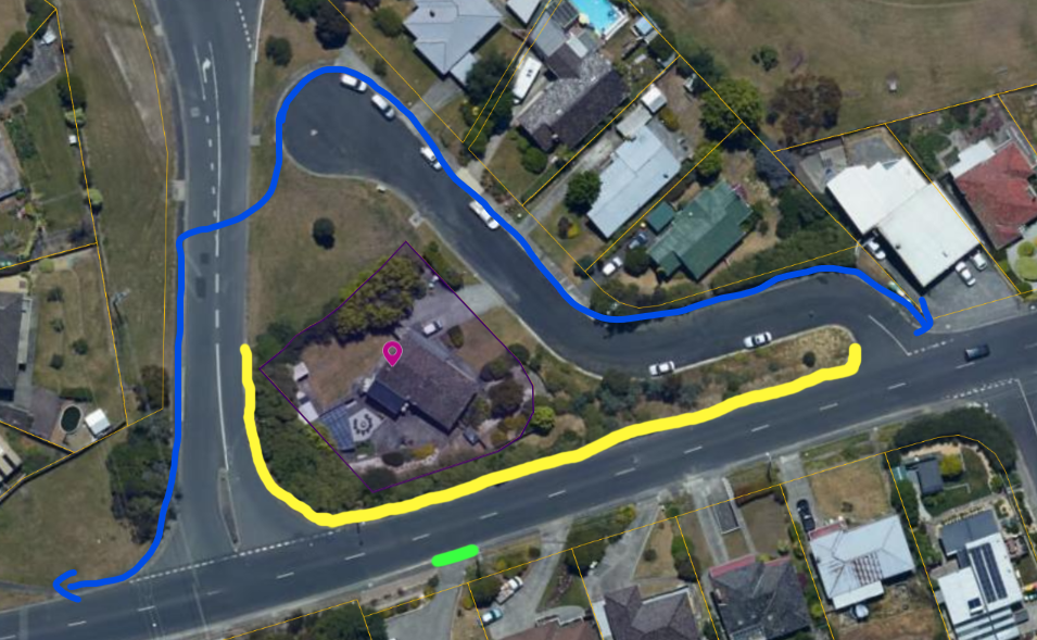
While their suggestion at first glance appears reasonable, the alternative route is unlikely to improve the situation.

  • Not only does the detour add distance to the walk (increase from 160m to 230m) , it takes the pedestrian left into Crosby down a slope and back up a short steep slope to Marys Hope. A slope steep enough to discourage anyone with mobility issues.
  • The detour could be used by walkers now but is not. Walkers are willing to accept the greater risk in crossing Marys Hope rather than the additional distance and effort in the alternative. If walkers found the alternative acceptable they would use it now. They don’t.
  • People walking to the bus stop next to the shop will regularly walk on the road along the yellow line because it is the shortest route. The quality of bus services is such that they dare not risk a half-hour wait for the next bus.
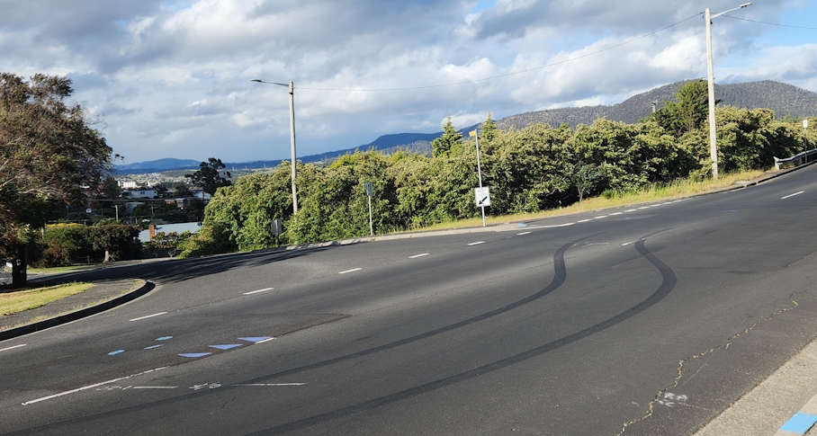
One driveway entrance forces anyone with a mobility issue to walk on the roadway. The Australian standard AS2890.1 provides guidelines for off-street parking design. In particular, it specifies for “access driveways near property boundaries” a “maximum gradient across property lines is 1 in 20 (5%)”.

And if the single footpath is blocked, the pedestrian is forced onto the roadway. Once there they have traffic approaching from behind.

Here is an image of a recent situation. The driveway I’ve mentioned above is in the foreground of the photograph.

Footpath closed near Marys Hope and Crosby October 2025.

The Australian Government has for years run an annual grant program, the Black Spots Program (BSP), designed to improve road safety across Australia. Anyone (even me personally) can nominate a place as a Black Spot. But in the Tasmanian context, unless a nomination is made or directly supported by the local council, it has little chance of success.

According to the guidelines a Black Spot is “an area or stretch of road where serious crashes have occurred, or are at risk of occurring.”

While the eligibility criteria refer to “a proven history of casualty crashes”, they also

“recognise that there are road locations that could be considered as ‘accidents waiting to happen’. Therefore, some program funds may be used to treat sites where road traffic engineers have completed a Road Safety Audit or Safe Systems Assessment or equivalent report, and found that remedial work is necessary. This allows an opportunity for proactive safety works to be undertaken before casualties occur.”

Pedestrians are barely mentioned in the documentation relating to the Black Spot Program. The emphasis is clearly on the danger to those in vehicles, not those hit by the vehicles. But the situation I’ve described above contains the greatest risk to those walking along and across the roadway.

I believe there is sufficient evidence to make a good case for a formal safety assessment of that intersection as a first stop toward nomination for the Black Spot Program.

Now for a Walking Infrastructure Plan

Katoomba Crescent laneway (entrance on Katoomba Crescent). 15/7/2025.

At its June 2025 open meeting council “endorsed” (whatever that means) the final draft of a Glenorchy Cycling Infrastructure Plan (GCIP) which contained no timeline, no description of what type of infrastructure might be where, and consequently no budget. It is in effect a vision for where cycling infrastructure might sit geographically long-term, but without any of the data needed to make a Priority Project. Still better than nothing and sufficient to satisfy, for now, the well organized lobby groups (such as Cycling South and Tasmanian Bicycle Council) in southern Tasmania.

By carefully reading the GCIP you will find the word “walking” mentioned 38 times, usually in the phrase “walking and cycling”. It seems the authors believed that the GCIP might serve as an infrastructure plan for all active transport, not just cycling.

It takes a few moments of thought to realize that those who walk have vastly different needs and considerations from those who ride. But it is not at all clear how those who often or mostly walk have their differing needs recognized by any level of government. There is a Facebook page “Pedestrian & Public Transport Users Group” that appears to focus exclusively on public transport. A recent addition is an organization known as Hobart Streets which shows some promise. So no organized lobby groups for those who walk.

Let me clear. I am not talking about tracks or trails designed purely for sport or recreation. Council already takes management of walking trails seriously, so seriously that you could say that Council has 4 R’s – Roads, Rates, Rubbish, and Recreation – instead of the usual three. I am talking primarily about people using “walking” as a way of getting about in their day-to-day life. To the shops. To the bus stop. To visit. To work. To school. To play sport. To the doctor. To study. etc. etc.

Infrastructure

It is easy to forget that there is a great deal of infrastructure in our city whose prime purpose is to cater for pedestrians. We drive past it. We walk over it. We can easily take it for granted.

Footpaths are the most ubiquitous. They are everywhere, well almost everywhere, and council does have policy documents related to them. The basic Footpaths Policy provides “guidance on the standards required for the provision and construction of footpaths and kerb ramps”. That policy refers to a footpath hierarchy defined exactly as follows:

  • Category 1 – CBD: footpaths in the main street in the CBD where there is significant business and pedestrian activity.
  • Category 2 – Primary: high pedestrian activity within the CBD areas and includes direct pedestrian links between the key CBD zones, such as the Intercity Cycleway.
  • Category 3 – Secondary: footpaths that provide the best link between key destinations and facilities (e.g. bus stops, local shops, schools, playgrounds, etc.)
  • Category 4 – Local: footpaths generally in the residential streets and any footpaths which are not included in the other categories above.

Notice the reference to the Intercity Cycleway as a “footpath”. Any regular user of the cycleway would regard it as “contested” in terms of whether pedestrians or cyclists have priority.

The Footpaths Policy also states that a “digital map of footpath hierarchy will be … maintained by Council”. It would be similar to the map underlying the Cycling Infrastructure Plan but not developed with any public consultation. The only map in Council’s map website is the Infrastructure Map which shows roads and kerbs but no footpaths.

The Footpath Trading Policy and Guidelines concern how businesses can operate on footpaths.

But there is much more infrastructure which exists to serve pedestrians.

  • Bus stop approaches (frequent destinations)
  • Kerbs (including ramps, kerb cuts and extensions)
  • Laneways and paths crossing blocks (e.g. Katoomba Crescent lane way)
  • Pedestrian crossings (with or without signals)
  • Pedestrian overpasses (e.g. Brooker near Montrose Bay) and underpasses (e.g. Brooker near Strathaven)
  • Pedestrian priority streets (access by vehicles limited and low speed)
  • Pedestrian refuge islands
  • Pedestrian safety and comfort (e.g. lighting, shelter)
  • Pedestrianized streets (vehicles excluded)
  • Rules regarding pedestrian priority (or not)
  • Spaces shared with cyclists (separate?)
  • Wayfinding (signage etc)

All this pedestrian-oriented infrastructure demands a pedestrian-oriented Infrastructure Plan.

Taking the bigger view

Before people walk, they think about how they will get from the starting point to the destination – everything in between – the route.

It is time for council to think the same way, in terms of routes, not simply individual pieces of infrastructure mitigating local issues.

It is time for walking infrastructure to be planned using routes as the primary focus, not apparently piecemeal addition here and there according to demands or complaints from residents.

Planning could in fact move to the next level via networks where integration and interconnection of major walking routes comes into play. This approach has been used elsewhere (such as Victoria (Australia), Queensland, and Dundee (Scotland)) so it has been tried and tested elsewhere.

A focus on the elderly

It is generally accepted that pedestrians are the most vulnerable road users. And older pedestrians are the most likely to be injured or killed in a crash. Furthermore, most demographic projections predict an increase in the proportion of older people in Glenorchy’s population. The State government’s Population Policy website says that for Glenorchy the “population of people aged 65 and above is projected to increase from 8,862 (17.4% of the LGA population) in 2023 to 12,074 (22.2%) in 2053.”

Clearly when considering pedestrian safety on roads, there must be a focus on the particular vulnerabilities of the older members of our community.

In conclusion

An interesting possible result of this type of planning is that it might trigger applications to the Black Spot Program for “walking” black spots in addition to the current almost exclusively “driving” black spots?

The State Government in their Active Transport Strategy tends to universally use the phrase “walking, wheeling and riding” as if they have identical requirements in all contexts. While many cycling and walking routes will overlap, the needs of pedestrians and cyclists differ dramatically and may even conflict.

Those differences demand a Walking Infrastructure Plan specifically designed for those for whom walking is important. Yes – a Glenorchy Walking Infrastructure Plan. The absence of an active lobby group should not delay council. Work must begin immediately.


Original sources

1. Council Footpaths Policy (downloaded 4/7/25)
https://www.gcc.tas.gov.au/wp-content/uploads/2024/10/Footpaths-Policy-2024-.pdf

2. Footpath Trading Policy (downloaded 4/7/25)
https://www.gcc.tas.gov.au/wp-content/uploads/2022/06/Footpath-Trading-Policy.pdf

3. Footpath Trading Guidelines (downloaded 4/7/25)
https://www.gcc.tas.gov.au/wp-content/uploads/2022/06/Footpath-Trading-Guidelines.pdf

4. “Planning for Walking”, Chartered Institution of Highways and Transportation 2015
https://www.ciht.org.uk/media/4465/planning_for_walking_-_long_-_april_2015.pdf

5. Victoria Walks – https://www.victoriawalks.org.au

6. Public domain map showing laneways and cycleways – https://www.openstreetmap.org/#map=14/-42.81996/147.25748&layers=C

End.

Make the KGV car park safe for walkers

Most of the conversation to date about the proposed replacement for the Glenorchy War Memorial Pool has focused on the internal design of the facility – the various architectural components – with little concerning its surroundings.

The observant reader will have noticed that the Intercity Cycleway comes within a few metres of the entrance of the proposed replacement for the current Glenorchy War Memorial Pool.

A major active transport route coming within a stone’s throw of a proposed major recreation centre with no safe connection defies logic.

There is currently no way to walk from the cycleway to either the entrance of the Tasmanian Transport Museum or the entrance of the Glenorchy Pool without crossing a roadway and potentially dealing with traffic. Some painted walkways across the nearby car park seem to exist only to help those who park there and then cross the railway lines to go to shop or work in the Glenorchy CBD. The car park is unfriendly to pedestrians. Council’s own Glenorchy Parking Strategy 2017-2027 makes it very clear that “Well-designed parking improves … pedestrian safety”. Council must make it safe.

Many council policies mention Council’s enthusiasm for active transport – walking, riding, scooting, running, etc. One of the more recent is the Active Glenorchy 2040 Framework for Sport and Recreation Infrastructure published in 2021.

The new facility provides an ideal opportunity to take advantage of the cycleway to promote active transport; in fact, to make the cycleway the preferred method for people to get to the pool.

To encourage this approach, patrons need a secure facility where they can lock up their bikes etc. CCTV would reassure those worried about theft.

Even if patrons don’t use the cycleway to go all the way from home to pool, some might be willing and able to park nearby and walk the last few hundred metres. Not so much a park and ride, more a park and walk. To allow this in all weathers, shelter needs to be provided along the cycleway – shelter against the heat and the cold. There is virtually none now.

There is or was apparently a Master Plan for a King George V Sports and Community Precinct Master Plan. It focussed entirely on places for people to go, the facilities, but nothing about how they can safely move around.

The close proximity of the cycleway to the Transport Museum and proposed pool gives council an opportunity to add a vital link to the pedestrian network in the city. Council need not wait for the construction of the new pool. It must plan the link immediately.