Tag Archives: infrastructure

Now for a Walking Infrastructure Plan

Katoomba Crescent laneway (entrance on Katoomba Crescent). 15/7/2025.

At its June 2025 open meeting council “endorsed” (whatever that means) the final draft of a Glenorchy Cycling Infrastructure Plan (GCIP) which contained no timeline, no description of what type of infrastructure might be where, and consequently no budget. It is in effect a vision for where cycling infrastructure might sit geographically long-term, but without any of the data needed to make a Priority Project. Still better than nothing and sufficient to satisfy, for now, the well organized lobby groups (such as Cycling South and Tasmanian Bicycle Council) in southern Tasmania.

By carefully reading the GCIP you will find the word “walking” mentioned 38 times, usually in the phrase “walking and cycling”. It seems the authors believed that the GCIP might serve as an infrastructure plan for all active transport, not just cycling.

It takes a few moments of thought to realize that those who walk have vastly different needs and considerations from those who ride. But it is not at all clear how those who often or mostly walk have their differing needs recognized by any level of government. There is a Facebook page “Pedestrian & Public Transport Users Group” that appears to focus exclusively on public transport. A recent addition is an organization known as Hobart Streets which shows some promise. So no organized lobby groups for those who walk.

Let me clear. I am not talking about tracks or trails designed purely for sport or recreation. Council already takes management of walking trails seriously, so seriously that you could say that Council has 4 R’s – Roads, Rates, Rubbish, and Recreation – instead of the usual three. I am talking primarily about people using “walking” as a way of getting about in their day-to-day life. To the shops. To the bus stop. To visit. To work. To school. To play sport. To the doctor. To study. etc. etc.

Infrastructure

It is easy to forget that there is a great deal of infrastructure in our city whose prime purpose is to cater for pedestrians. We drive past it. We walk over it. We can easily take it for granted.

Footpaths are the most ubiquitous. They are everywhere, well almost everywhere, and council does have policy documents related to them. The basic Footpaths Policy provides “guidance on the standards required for the provision and construction of footpaths and kerb ramps”. That policy refers to a footpath hierarchy defined exactly as follows:

  • Category 1 – CBD: footpaths in the main street in the CBD where there is significant business and pedestrian activity.
  • Category 2 – Primary: high pedestrian activity within the CBD areas and includes direct pedestrian links between the key CBD zones, such as the Intercity Cycleway.
  • Category 3 – Secondary: footpaths that provide the best link between key destinations and facilities (e.g. bus stops, local shops, schools, playgrounds, etc.)
  • Category 4 – Local: footpaths generally in the residential streets and any footpaths which are not included in the other categories above.

Notice the reference to the Intercity Cycleway as a “footpath”. Any regular user of the cycleway would regard it as “contested” in terms of whether pedestrians or cyclists have priority.

The Footpaths Policy also states that a “digital map of footpath hierarchy will be … maintained by Council”. It would be similar to the map underlying the Cycling Infrastructure Plan but not developed with any public consultation. The only map in Council’s map website is the Infrastructure Map which shows roads and kerbs but no footpaths.

The Footpath Trading Policy and Guidelines concern how businesses can operate on footpaths.

But there is much more infrastructure which exists to serve pedestrians.

  • Bus stop approaches (frequent destinations)
  • Kerbs (including ramps, kerb cuts and extensions)
  • Laneways and paths crossing blocks (e.g. Katoomba Crescent lane way)
  • Pedestrian crossings (with or without signals)
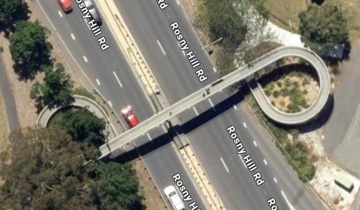
  • Pedestrian overpasses (e.g. Brooker near Montrose Bay) and underpasses (e.g. Brooker near Strathaven)
  • Pedestrian priority streets (access by vehicles limited and low speed)
  • Pedestrian refuge islands
  • Pedestrian safety and comfort (e.g. lighting, shelter)
  • Pedestrianized streets (vehicles excluded)
  • Rules regarding pedestrian priority (or not)
  • Spaces shared with cyclists (separate?)
  • Wayfinding (signage etc)

All this pedestrian-oriented infrastructure demands a pedestrian-oriented Infrastructure Plan.

Taking the bigger view

Before people walk, they think about how they will get from the starting point to the destination – everything in between – the route.

It is time for council to think the same way, in terms of routes, not simply individual pieces of infrastructure mitigating local issues.

It is time for walking infrastructure to be planned using routes as the primary focus, not apparently piecemeal addition here and there according to demands or complaints from residents.

Planning could in fact move to the next level via networks where integration and interconnection of major walking routes comes into play. This approach has been used elsewhere (such as Victoria (Australia), Queensland, and Dundee (Scotland)) so it has been tried and tested elsewhere.

A focus on the elderly

It is generally accepted that pedestrians are the most vulnerable road users. And older pedestrians are the most likely to be injured or killed in a crash. Furthermore, most demographic projections predict an increase in the proportion of older people in Glenorchy’s population. The State government’s Population Policy website says that for Glenorchy the “population of people aged 65 and above is projected to increase from 8,862 (17.4% of the LGA population) in 2023 to 12,074 (22.2%) in 2053.”

Clearly when considering pedestrian safety on roads, there must be a focus on the particular vulnerabilities of the older members of our community.

In conclusion

An interesting possible result of this type of planning is that it might trigger applications to the Black Spot Program for “walking” black spots in addition to the current almost exclusively “driving” black spots?

The State Government in their Active Transport Strategy tends to universally use the phrase “walking, wheeling and riding” as if they have identical requirements in all contexts. While many cycling and walking routes will overlap, the needs of pedestrians and cyclists differ dramatically and may even conflict.

Those differences demand a Walking Infrastructure Plan specifically designed for those for whom walking is important. Yes – a Glenorchy Walking Infrastructure Plan. The absence of an active lobby group should not delay council. Work must begin immediately.


Original sources

1. Council Footpaths Policy (downloaded 4/7/25)
https://www.gcc.tas.gov.au/wp-content/uploads/2024/10/Footpaths-Policy-2024-.pdf

2. Footpath Trading Policy (downloaded 4/7/25)
https://www.gcc.tas.gov.au/wp-content/uploads/2022/06/Footpath-Trading-Policy.pdf

3. Footpath Trading Guidelines (downloaded 4/7/25)
https://www.gcc.tas.gov.au/wp-content/uploads/2022/06/Footpath-Trading-Guidelines.pdf

4. “Planning for Walking”, Chartered Institution of Highways and Transportation 2015
https://www.ciht.org.uk/media/4465/planning_for_walking_-_long_-_april_2015.pdf

5. Victoria Walks – https://www.victoriawalks.org.au

6. Public domain map showing laneways and cycleways – https://www.openstreetmap.org/#map=14/-42.81996/147.25748&layers=C

End.

Now make it safe for pedestrians at Montrose Bay

Now that the efforts of Council and others appear to have finally persuaded the State Government to make the Montrose Bay Park entrance safer for drivers, maybe it can do the same for those who do not drive.

The State Government allocated funds for a project to improve safety at the intersection. The Department of State Growth (DSG) have had a draft design for the intersection to make it controlled by traffic lights. They’ve had that design on their books for years. Enquiries to DSG have always elicited the same response – “we’re waiting for the funds”.

The State Government (and many others) will claim that the proposed traffic lights will make the intersection safe for those on foot, on bike, on scooter, or on skateboard – in other words, for what is now called “active transport”.

Most who have attempted to cross the Brooker Highway on foot will tell a story of being extremely cautious, extremely nervous, extremely tentative. And they will say that using traffic lights does little to reduce the tension. 

Any reasonable person could easily come to the conclusion that the Brooker Highway has one prime purpose – to allow traffic to enter and leave Greater Hobart as quickly as possible. It is a facility for traffic. It is utterly ludicrous to suggest that the Highway was in any way designed for the safety of people moving around in any other way, certainly not on foot.

So the proposed traffic lights may help drivers feel safer at Montrose Bay but will do little for pedestrians.

Which brings me to the pedestrian overpass at Montrose Bay High School. The only place in a two kilometre stretch of highway where you can cross without walking on the road surface.

A passing glance at the overpass might fool a casual observer that the overpass is the solution. And it is in roughly the right place, not too far from the school and Montrose Bay Park.

View of pedestrian overpass at Montrose Bay High School facing north. 2025.

But on a second glance, the sets of stairs on each side of the highway will become evident. Those stairs are an impassable barrier for anyone with any significant mobility issues.

That problem has been recognized officially. That overpass is not DDA-compliant, in other words, not compliant with the Commonwealth Disability Discrimination Act 1992. This is after all what the State Govt’s own Brooker Highway Transport Plan said back in February 2011.

You might look at its title and think that the DDA is just for the disabled. Not so. It is all about access. It is about everyone having the right to “have access to places used by the public”.

To learn more about the DDA, take a look at the website of the Australian Human Rights Commission.

To see an aerial view of a compliant overpass you need go no further than Bellerive.

Pedestrian overpass on Rosny Hill Road 2025.

It has become clear over many years that no state government of any political persuasion has had any interest in the safety of pedestrians on or around the Brooker Highway. Their strategy has been to stonewall any request for change and rely on lobbyists giving up in frustration.

Council must now add the provision of a DDA compliant overpass to its priority list for funding.

It must not put up the white flag on the safety of its residents – and everyone else from the region – who go to the high school or park.

Traffic calming in Glenorchy … unlikely

At about 11pm on 25 July 2023, a crash involving two cars and a telegraph pole took place in Marys Hope Road 25 metres from my home. Both cars were seriously damaged. The power pole was pulled out of the ground and left suspended in the air between the poles on either side. Police, ambulance, and a fire engine attended. Tasnetworks worked through the night to finally restore power by sunrise.

This crash reminded me of the many other occasions when we have heard or seen vehicles speeding up or down the road, and how every time it happened we wondered what could be done to stop it happening (or at least make it less frequent).

I’d noticed speed humps in Katoomba Crescent in Rosetta. Another flat top road hump in Nathan St, Berriedale. I’d noticed broader flat speed humps at Cornelian Bay near the waterfront.

So I emailed council asking that they consider modifying Marys Hope Road with some sort of traffic calming like speed humps (narrow or broad and flat) to make it very difficult or uncomfortable for drivers to speed.

The response very politely explained why that was never going to happen, primarily because Marys Hope Road is a collector road, and secondly because Council relies absolutely on external funding to construct traffic calming.

It also mentioned that Council was within the month going to put out proposals for speed limit reductions for public consultation – including one for Marys Hope Road. But its effect would be to reduce the speed limit and change some speed limit signs. No mention of road calming.

Which brings me to Council’s current Traffic Calming Devices policy. The emails from Council hadn’t mentioned this policy, and when I read it, I could see why.

The first version of this policy was adopted in 2016. We are now on version three. There was no public consultation for any version of this policy. According to the agenda item for its first review in 2019 the reason is that the “policy itself provides for a four-week period of community consultation wherever it is proposed to install traffic calming devices in a street.”

Yes – public consultation for a speed hump.

Council undertakes most roadworks with no public consultation. Council determines which locations it will propose for Black Spot grants. The public has no say. Council spent more than a quarter of a million dollars on a 300 metre footpath from the cycleway to the Granada opposite MONA (almost a thousand dollars per metre) without public consultation.

Why is traffic calming treated differently? So differently that the policy dictates that the decision to construct traffic calming must be decided by the councillors around the table (if it gets over all the other hurdles placed in its way by the policy). Yes, a proposal for a speed hump must come to an Open Council meeting.

Council makes difficult decisions, financial and otherwise. It can apparently disband an entire economic development team but cannot decide to build a speed hump without asking the public.

It is disappointing in this case to see Council apparently granting more importance to the occasional complaint from the public experiencing some minor inconvenience through being unable to travel at their desired speed – than to public safety.

In fact, the primary purpose of Council’s Traffic Calming Devices policy appears to be to make it more difficult to implement traffic calming. The policy in a section “Background” is completely negative about traffic calming. The entire document seems to obsess over “hooning”.

It claims to provide “a policy position and to develop a consistent and practical approach in the management of road humps and other traffic calming devices”. What it actually does is discourage residents from bothering Council with requests for traffic calming (and encourage them to take their hooning complaints elsewhere).

Council needs to decide whether the proposed changes to speed limits are simply to remove an anomaly on the speed limit map OR to actually reduce traffic speed and improve safety.

If council is serious about safety on the roads, it must scrap the current Traffic Calming policy and begin to produce a new policy that focuses on public safety and involves public consultation.

A policy that makes clear the actual likelihood of action.

A policy which does not give the reader false hope.

Version 3 of Council’s policy on “Traffic Calming Devices” (downloaded on 22/3/24 from https://www.gcc.tas.gov.au/traffic-calming-devices-policy-2021-final/ ).

Open council meeting agenda item for 2019 review of policy (downloaded on 22/3/24 from http://glenorchy.infocouncil.biz/Open/2019/04/OC_29042019_AGN.PDF – pages 49-50) and report for agenda item (downloaded on 22/3/24 from http://glenorchy.infocouncil.biz/Open/2019/04/OC_29042019_ATT.PDF – pages 69-72 )